
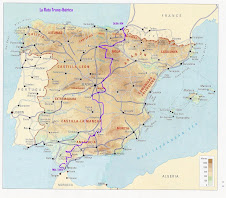
Logistically, picking a route that goes from the north of Spain to the extreme south should be a piece of cake; it should be a straight shot right down the middle of the peninsula, from one end to the other. When I originally envisioned the route, I thought about what the easiest way would be to get from north to south without having to deal with too much traffic.
In fact, it hasn't been that easy. I call it the Moncho Test; Moncho Dávila(pictured right), the designer responsible for the Spanish Cyclepaths (http://www.spanishcyclepaths.com/) website, just had a baby. His girlfriend, Marta, isn't as avid a cyclist as he is, so going on a biking trip for them posing several challenges. They need to find a route which isn't too hilly or too hard to ride; after all, only one of the three of them is an experienced cyclist who likes hills. Infrastructure is important: they can't be that far away from hotels and places to eat. And it's gotta be fun. Dedicated cycle tourists don't mind kilometres and kilometres of boring sights, since they know that, eventually, something cool will come up. Not everyone is that patient.
So when it came to deciding on the route, I decided that it would be much more appealing to set a route that followed simple guidelines:
a) Does it keep you away from major roads? After all, a ride isn't enjoyable if you're worried that you're going to get dinged from behind.
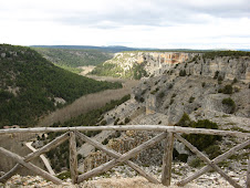
b) Is it going to take you to places that you wouldn't normally go to if you were travelling by car? Sure, the supposed advantage of having a car means that you should be able to go where you want. But many times, we focus so much on reaching our destinations that we don't think about the fun stuff to see along the way. The Trans-Iberian goes through and by some of the most important - and least visited - sights in Spain. That doesn't mean that the route goes through the middle of nowhere - but it's a great way to get away from the tourist trail and see some beautiful art, architecture and areas.
c) Can you use public transit to get there and back? There are two reasons for this: first of all, relatively few people are going to have five weeks to do the entire route - they're much more likely to do a weekend here, a week there. The second reason: taking a bike in a car is a lot more hassle than taking a bike on public transit. That's not to say that taking a bike on a bus or train in Spain is easy. It's a lot nicer than having to plan a circular route that takes you back to your car (which could get broken into while you're away) or having to worry about whether your bike(s) will fit into your vehicle.
d) Does it use already-existing green tourism infrastructure and facilities? I love rail trails, the Camino de Santiago and transhumance routes, but it's always surprised me that no one has thought to connect them on a national level and create a national system. Until I win the lottery and can afford to put up signage all over the nation (and that's going to be a long time coming, I suppose) there's no reason why the route can't incorporate infrastructure that's already there.
So those were the four criteria I used when thinking about the route. Stay tuned to find out how the route's evolving and where we'll eventually go in March of 2008.


No comments:
Post a Comment